 Kontakt
 Wie einkaufen
Versand
Kaufberater
 Englisch
 55 b
55 b
 Demnächst
 Neu
Neu
Bis zu 30 Tage Rückgaberecht
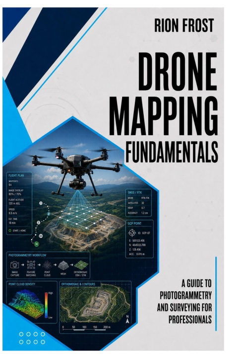
Drone Mapping Fundamentals is a practical guide to using drones for photogrammetry, surveying, aerial data collection, and professional mapping workflows.
This book explains how drone mapping works from planning to data capture, helping readers understand the connection between flight preparation, image overlap, ground control points, camera settings, field accuracy, orthomosaic creation, elevation models, and survey-ready outputs. Instead of treating drone mapping as simply flying over a site, it shows how careful planning and repeatable workflows can improve data quality and reduce costly mistakes.
Inside, readers will learn about mapping flight plans, photogrammetry basics, site preparation, field checklists, image collection, georeferenced imagery, terrain models, construction documentation, inspection workflows, and the role of GIS in professional drone mapping. The focus is practical and professional, giving readers a clear foundation for safer and more accurate aerial survey work.
Written for drone pilots, survey technicians, GIS learners, construction professionals, inspection teams, students, and UAV operators, this guide provides a structured introduction to the tools and decisions behind drone-based mapping.
Whether you are learning photogrammetry, preparing for field mapping work, or improving your aerial survey workflow, this book will help you understand the fundamentals behind reliable drone mapping.
Buy this book today and start learning how to plan, capture, and understand drone mapping data with more confidence.


Informationen zum Buch
Englisch

Verschenken Sie dieses Buch noch heute
Es ist ganz einfach
1 Legen Sie das Buch in Ihren Warenkorb und wählen Sie den Versand als Geschenk 2 Wir schicken Ihnen umgehend einen Gutschein 3 Das Buch wird an die Adresse des beschenkten Empfängers geliefertHallo! Ich bin Libroamiko, dein Buchberater.
Wie kann ich dir helfen?